


Navigraph Charts

توضیحات Navigraph Charts
Are you into flight simulation? Navigraph Charts is the preferred charts app in the flight simulation community offering the largest coverage available of Jeppesen charts updated continuously every 28 days following the AIRAC cycle.
Navigraph Charts allows you to search, view and organize airport charts from 6,800 airports around the globe. You can connect it to FSX, Prepar3D or X-Plane, to plot your position on charts, or use it independently to plan your route.
Navigraph Charts contains the following features:
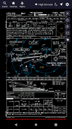
- Worldwide and current Jeppesen IFR charts: 6,800+ airports covered (requires Navigraph subscription)
- Moving maps: connect to X-Plane, FSX and Prepar3D to show the simulator's aircraft position on the charts in real time (requires Navigraph Simlink on simulator computer)
- Night mode: Dark theme version of the charts for low ambient light conditions
- Route calculation: Automatically calculate a route between any airport pair directly in the app
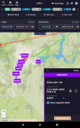
- SID and STAR visual overviews: View airport procedures overlaid on the enroute chart for better understanding of the airspace and more straightforward flight planning
- Flight organization: Interactively display the flight's route on the enroute chart, and collect charts for departure, destination and alternates in a single place
- Chart overlays: Overlay SID, STAR and approach charts on the enroute chart for easier transitions between different envelopes of the flight and for increased situational awareness
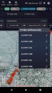
- Chart color coding and pinboards: Easily filter specific chart types and pin charts for quick access
- Interactive enroute charts: Click and search airports, waypoints, navaids, airways, controlled and restricted airspaces, FIRs/UIRs, holding patterns and more
- Flight plan import: Import flight plans from SimBrief and other external route calculator tools
For the ultimate experience we recommend subscribing to Navigraph Ultimate which ensures that you are always flying using the most recent charts and navdata used by all online pilots and air traffic controllers in the flight simulation community.
Navigraph Ultimate includes, in addition to worldwide charts access, updated navdata parsed into more than 120 different addon formats including aircraft like PMDG B737/747/748/777, Qualitywings B787, Flight Factor A320, IXEG 737 and many more. Navigraph Ultimate also includes regular updates to the navigation databases in flight simulators such as X-Plane 11.
Please note that:
- This product is for home flight simulation use only and must not be used for real world navigation
- This product is free to use in demo mode but requires a Navigraph account
- This product requires a Navigraph Charts or Navigraph Ultimate subscription for full access to all airport charts
Pro tips:
- We recommend that you install Navigraph Charts on your desktop too. All changes you make to Flights, Favorites and Pinboards are immediately reflected on your tablet
- With a current Navigraph Charts or Navigraph Ultimate subscription you can also access airport charts in the virtual Electronic Flight Bag (EFB) on the virtual flightdeck of many addon aircraft
آیا شما به شبیه سازی پرواز؟ نمودارهای ناجی نمودار برنامه برتر در جامعه شبیه سازی پرواز ارائه شده است که بزرگترین پوشش موجود Jeppesen نمودار به طور مداوم در هر 28 روز پس از چرخه AIRAC به روز شد.
Charts Navigraph اجازه می دهد تا شما را به جستجو، مشاهده و سازماندهی نمودار فرودگاه از 6،800 فرودگاه در سراسر جهان. شما می توانید آن را به FSX، Prepar3D یا X-Plane وصل کنید تا موقعیت خود را در نمودارها قرار دهید یا از مسیر آن به صورت مستقل استفاده کنید.
Charts Navigraph شامل ویژگی های زیر است:
- نمودارهای جهانی و جیپسن IFR: 6،800+ فرودگاه تحت پوشش (نیاز به اشتراک Navigraph)
- حرکت نقشه ها: به X-Plane، FSX و Prepar3D متصل شوید تا موقعیت هواپیما شبیه ساز را در نمودار در زمان واقعی نشان دهید (نیاز به Navigraph Simlink در رایانه شبیه ساز)
- حالت شب: نسخه تم تیره از نمودار برای شرایط نور محیط کم
- محاسبه مسیر: به صورت خودکار محاسبه مسیر بین هر جفت فرودگاه مستقر در برنامه
- مرور کلی بصری SID و STAR: مشاهده رویه های فرودگاه بر روی نمودار مسیر برای درک بهتر از فضای هوایی و برنامه ریزی آسان تر پرواز
- سازمان پرواز: به صورت تعاملی مسیر پرواز بر روی نمودار مسیر را نشان می دهد و نمودارها را برای خروج، مقصد و جایگزین در یک مکان جمع آوری می کند
- پوششهای نمودار: روی SID، STAR و نمودارهای روتاری روی نمودار موجود برای انتقال آسانتر بین پاکتهای مختلف پرواز و برای افزایش آگاهی موقعیتی
- برنامه نویسی رنگ نمودار و ریزه کاری: به راحتی انواع نمودار های خاص و نمودار پین را برای دسترسی سریع فیلتر کنید
- نمودارهای مسیریابی تعاملی: کلیک کنید و جستجو فرودگاه ها، ایستگاه های راه، navaids، راه های هوایی، فضای هوایی کنترل شده و محدود، FIR ها / UIRs، برگزاری الگوهای و بیشتر
- برنامه واردات پرواز: برنامه های پرواز پرواز از SimBrief و دیگر ابزار ماشین حساب خارجی را وارد کنید
برای تجربه نهایی ما توصیه می کنیم به اشتراک گذاری Navigraph Ultimate که تضمین می کند که شما همیشه پرواز با استفاده از نمودار های جدید و navdata استفاده شده توسط تمام خلبانان آنلاین و کنترل ترافیک هوایی در جامعه شبیه سازی پرواز است.
Navigraph Ultimate شامل علاوه بر دسترسی به نمودارهای جهانی، Navdata به روز شده در بیش از 120 فرمت مختلف افزودنی از جمله هواپیماهای مانند PMDG B737 / 747/748/777، Qualitywings B787، Flight Factor A320، IXEG 737 و بسیاری دیگر را تجزیه می کند. Navigraph Ultimate همچنین شامل به روز رسانی های منظم پایگاه های ناوبری در شبیه ساز پرواز مانند X-Plane 11 می باشد.
لطفا توجه داشته باشید که:
- این محصول فقط برای استفاده از شبیه سازی پرواز خانگی است و نباید برای ناوبری واقعی جهان استفاده شود
- این محصول رایگان است برای استفاده در حالت نسخه ی نمایشی، اما نیاز به یک حساب کاربری Navigraph
- این محصول نیاز به یک نمودار ناویگرافی یا ناوبر نهایی برای دسترسی کامل به تمام نمودارهای فرودگاه دارد
راهنمایی های طرفدار:
- ما توصیه می کنیم که نمودارهای Navigraph را روی دسکتاپ خود نصب کنید. همه تغییراتی که به پروازهای، علاقه مندی ها و Pinboards می دهید، بلافاصله در رایانه لوحی شما منعکس می شوند
- با استفاده از چارت های جاری Navigraph یا اشتراک Navigraph Ultimate شما همچنین می توانید نمودار های فرودگاه را در صندوق پرواز الکترونیک مجازی (EFB) در پرواز پرواز مجازی بسیاری از هواپیماهای اضافی

Navigraph Charts - اطلاعات APK
نسخه APK: 7.0.3حزمة: com.navigraph.chartsآخرین نسخه Navigraph Charts
سایر نسخهها


اپلیکیشنها در دسته مشابه
 4.284.464.073.783.373.72
شاید دوست داشته باشید...


